
How to Locate Old Welsh Properties for Genealogy
Affiliate Disclaimer: this page uses affiliate links. I may earn commission on any sales made through these links.

If you have ever dabbled in Welsh genealogy, you've probably seen a census of England and Wales. These censuses are incredibly fun to explore, but an American researcher may be thrown off by the geography of it all. In U.S. censuses, addresses are written in the left margin: street name and house number. But in the censuses of England and Wales, addresses can be as vague as the colloquial name given to a property - a practice still used today! So what is a researcher to do when given only the name of a property and no other indicators to figure out where that property is today?
Use Coflein
Coflein.gov.uk is the online database for the National Monuments Record of Wales. Think of it as a searchable online catalogue of heritage sites throughout Wales. Among its collection are 50,000 historic maps to help you trace your Welsh ancestors back to their farms, and this blog post will teach you how to do that.
1. Locate your ancestors on a Welsh Census
First, locate your Welsh ancestor in a census of Wales - I use FindMyPast for all Welsh, English, and Irish records! The great thing about Welsh censuses is that they always give the name of the dwelling place, making locating your exact ancestral home that much easier. If you're used to researching in the US, you'll know that it can be pretty difficult to pin point exactly where in a given county or township your ancestor may have lived, because it wasn't until 1890 that the US federal census began to record house number and street names; even afterward 1890, these often weren't recorded in rural areas.
In Wales, however, the censuses recorded the name of the dwelling places beginning with the first census in 1841!
Take a look at this example page from the 1901 census:

On the far left column, it lists the names of the dwellings each family lived in. The family that I will use as an example here is the Davies family - family number 4 - who is listed as living at "Coedybrane".
How easy! But if you think you can just type “Coedybrane” in on Google and get a Google Map pin right on the farm...you'd be wrong. A quick search for Coedybrane on Google returns nothing. Remember that these are Welsh language place names and there is a good chance they were probably misspelled by an English-speaking census taker. A search for 'coedybrane' on Coflein also returns nothing. So, before you even turn to Coflein for research, there is one thing you should do:
2. Note the Neighbors
Take note of all the neighboring farms before you attempt to find your ancestors' farm on a map. In the above sample page, there are three other places: Penygelli Mill, Frolic, and Smithy. To be safe, note down the names of the farms on the previous and following pages, too. That way you'll have a hefty arsenal of places to research in the (likely) case that some of them are misspelled or in the case that Coflein doesn't have any information on them.
3. Look at the Enumeration District
To add to your arsenal of knowledge before you begin researching, take a look at the 'Description of the Enumeration District' page in the census. This page will expand on the places given in the census, telling you:
✅ Civil Parish(es)
✅ Ecclesiastical Parish(es)
✅ Rural District
✅ Parliamentary Borough
✅ Town, village, or hamlet
✅ Boundary of the Enumeration District
✅ Contents of the Enumeration District
Some of these land divisions, you'll notice, are listed at the top of the sample page above: Civil Parish of Kerry, Ecclesiastical Parish of the Holy Trinity of Sarn, Rural District of Newtown and Llanidloes, all within the County of Montgomery.
But, what that sample page doesn't tell you are the contents of the entire enumeration district; i.e. all the places listed in the census:
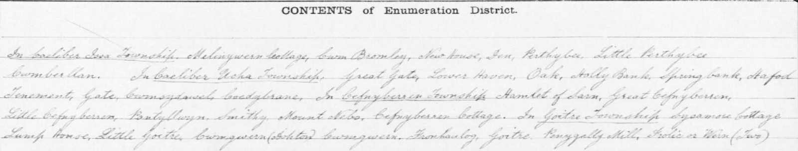
Armed with these contents, and the handful of names of the neighboring farms of your ancestors, you're bound to have luck on Coflein.
4. Search on Coflein.gov.uk
Once on coflein.gov.uk, direct your attention to the search bar. A good place to start in your search - if the exact farm, like Coedybrane, doesn't return any results - are the places listed within the contents of the district. Read through the list and find a place that you don't think would be misspelled: a short name or a name that sounds like it could easily also be English. In this case, I noticed a place named 'Mount Nebo', obviously named in English after the Biblical mountain in Jordan. I searched for Mount Nebo and was returned with two results:

Next I checked to see if either of the results' respective communities were related in any way to the enumeration district in which I was searching. The first result, 'Mount Nebo, Hillfort Near', is listed as located in the community of Kerry. Kerry also the name of the Civil Parish that the farm I am researching, Coedybrane, is listed in! Thus, it would appear that this may be the same Mount Nebo that is listed in the census alongside Coedybrane.
5. Explore the Map

Map from Coflein.gov.uk showing the location of Mount Nebo
When you click on a site name, it will bring you to an interactive map that will have the site’s exact location pin pointed. You will notice other places for which Coflein has information on are shown around it, and this is key. Look at the other places on the map, and see if they match up to any of the other places listed in the 'Contents of the Enumeration District' from the census you’re working with.
In this case, Mount Nebo is surrounded by places like Great Cefnyberin and Little Cefnyberin to the west, Sarn to the south, and Little Perth-y-bu to the northeast. Returning to the Contents list, it would appear that the locations on the map are the same locations in the census. Little Perth-y-bu is 'Little Perthybu' in the Contents list, and Cefnyberin is incorrectly spelled on the Contents list as 'Cefnyberren'. And Sarn, the town to the south of Mount Nebo on the map, shares its name with the Ecclesiastical Parish (Holy Trinity of Sarn) in which the census took place.
6. Find Your Farm
The next step is to just keep exploring the map until you find your farm. In this case, I scrolled past Little Cefnyberin to the west and came across a place called Coed-Y-Brain: undoubtedly the 'Coedybrane' where the family I am researching are listed as living:

Map from Coflein.gov.uk showing Coed-y-Brain
7. Locate on a Modern Map
Now that you've found the farm (or mill, or other type of place) where your family lived on the Coflein map, you can find it on a modern map and make a pin of it on Google My Maps so you always have it. In this case, I went to Google My Maps and searched for the town of Sarn within the county of Montgomery. According to the Coflein map, Coed-Y-Brain would be northwest of Sarn up Shop Lane (I got the street name by zooming in further in the Coflein map), just past where Shop Lane intersects with the closest river:
Based on the above calculation, I located where I thought Coed-Y-Brain should be located on Google My Maps:

8. Check the Satellite Map
One thing to remember about Wales, and the UK in general: it's old. Buildings tend to stick around. So once you think you have located the farm on a modern map, switch your Google My Maps viewer to 'satellite view' (left hand menu --> base map --> satellite) and see if your calculation is correct. In this case, it was; there was a collection of buildings right where I had calculated Coed-Y-Brain to be:

And, finally, turning to Google Maps Street View, I just had to see what those buildings looked like:

And there you go! Now you are able to take the name of any property on a Welsh census, pin it on a map, and see it in Google Street view. Let me know if you were able to find a Welsh property using this method by commenting below!